h o m e :: |
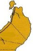
Location, Land Area and Political Subdivisions Cagayan lies in the northeastern part of mainland Luzon, approximately 17° 30' north and 121° 15' east, occupying the lower basin of the Cagayan River. Tuguegarao (now a component city), its capital is 483 kilometers north of Manila, about one hour by air travel, and ten hours by land, through the Maharlika Highway, also known as the Cagayan Valley Road--Region 02's trunkline road--which runs parallel to the Cagayan River. The Province, including the Babuyan island group, is approximately 900,270 hectares. It is the second largest in land area in Region 02 and constitutes about 3% of the total land area of the Philippines.
Cagayan is politically subdivided into 28 municipalities and one component city (Tuguegarao), with 820 barangays. Of the 28 municipalities, 2 are first-class municipalities, 2 are second-class municipalities, 4 are third-class municipalities, 14 are fourth-class municipalities, and 5 are fifth-class municipalities. Only Sta. Praxedes is a sixth-class municipality. The classification is income-based by the Department of Budget and Management. Cagayan is classified as a first-class province.
(Click map to enlarge) For administration purposes, Cagayan is divided into three congressional districts. The Third District includes the southern municipalities of Amulung, Iguig, Peńablanca, Tuguegarao City, Enrile, Solana and Tuao. All other towns west of the Cagayan River comprise the Second Congressional District, except for some parts of Aparri, Camalaniugan, Lallo, Alcala, and Amulung, which are found west of the Cagayan River. The rest of the municipalities comprise the First Congressional District, northeast of the Province.
guestbook :: forum :: contact :: site map :: site info |
||||||||||||||||||||||||||||||||||||||||||||||||||||||||||||||||||||||||||||||||||||||||||||||||||||||||||||||||||||||||||||||||||||||||||||||


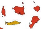
 The Balintang Channel, north of the Babuyan Islands, forms the boundary between the Provinces of Cagayan and Batanes. The Cagayan mainland has a level coastline on the north opening to the South China Sea and an irregular coastline on the east facing the Philippine Sea, the country's territorial waters of the Pacific Ocean. The Sierra Madre Mountains form its rugged and mountainous eastern coast, but its beaches and coves could be utilized for economic production. Cagayan is bounded on the south by the Province of Isabela. The Cordilleras enclose its hilly southwestern part, bordering the Province of Kalinga, and its low and swampy northwestern part, bordering the Province of Apayao.